As a pedagogical tool, the map remains remarkably effective. It anchors what might otherwise feel like an abstract sequence of battles and dynastic names to specific landscapes and territories, reminding us that history is always, ultimately, a story about people and the ground beneath their feet. For students of early medieval Britain, this plate from Muir’s Atlas is an indispensable point of departure.

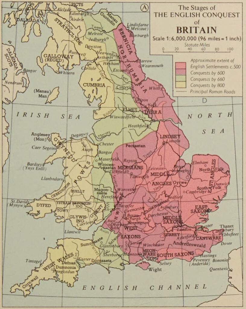
The map charts the advance of the Angles, Saxons, and Jutes following the collapse of Roman authority in Britain after 410 AD. Colour coding distinguishes the successive waves of conquest, allowing the reader to follow, decade by decade, how isolated beachheads on the eastern and southern coasts gradually merged into consolidated kingdoms. The early footholds of Kent, Sussex, and East Anglia give way, in later phases, to the sprawling dominions of Northumbria, Mercia, and Wessex — the great kingdoms that would define Anglo-Saxon England.
The map charts the advance of the Angles, Saxons, and Jutes following the collapse of Roman authority in Britain after 410 AD. Colour coding distinguishes the successive waves of conquest, allowing the reader to follow, decade by decade, how isolated beachheads on the eastern and southern coasts gradually merged into consolidated kingdoms. The early footholds of Kent, Sussex, and East Anglia give way, in later phases, to the sprawling dominions of Northumbria, Mercia, and Wessex — the great kingdoms that would define Anglo-Saxon England.
What is particularly striking is what the map reveals about the spaces the invaders did not yet hold. The western highlands — Wales, Cornwall, and the kingdom of Strathclyde — remain unshaded, preserving the memory of a Brittonic world that endured long after the east had been transformed. Place-name evidence and the survival of Celtic languages in these regions corroborate what the map’s blank spaces suggest: that the conquest was neither swift nor total.
The map also invites reflection on the nature of the process itself. “Conquest” is a word that flattens a far more complex reality of migration, displacement, assimilation, and coexistence. Muir’s cartographers necessarily simplify, drawing hard boundaries where the historical reality was porous and contested. Yet this simplification is also the map’s great virtue — it renders legible a transformation that unfolded over two centuries and across an entire island.
As a pedagogical tool, the map remains remarkably effective. It anchors what might otherwise feel like an abstract sequence of battles and dynastic names to specific landscapes and territories, reminding us that history is always, ultimately, a story about people and the ground beneath their feet. For students of early medieval Britain, this plate from Muir’s Atlas is an indispensable point of departure.